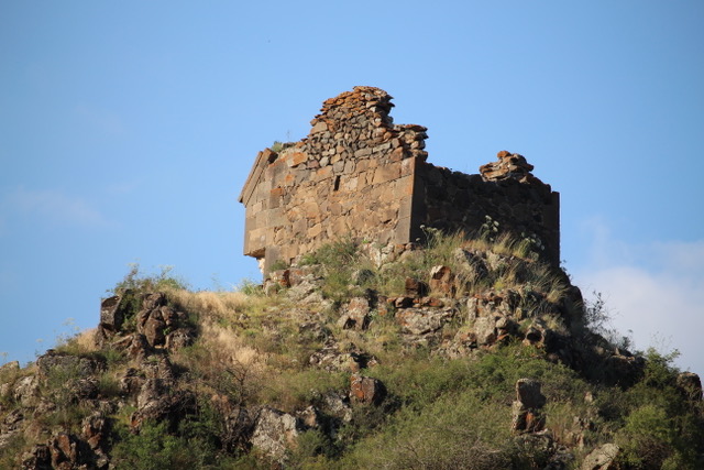
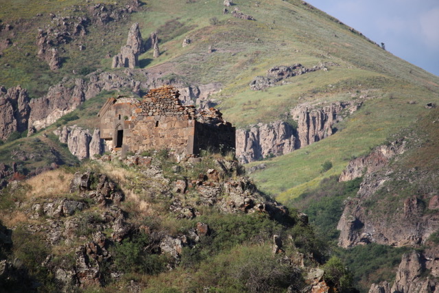
On my map of Armenia and Artsakh is a church named “Mknatami Khach,” which literally translates into “Mouse’s Tooth Cross.” The church is located in the Lachin Corridor, Kashatagh region, the first region encountered when entering Artsakh from Armenia over the Goris to Stepanakert highway.
This intriguing name prompted me and my friend Vova to search in vain for this church during visits to Artsakh for the past two years. This year was our third attempt. While our map showed the church, it lacked sufficient details to guide us there. Other than one main road heading north from the main Goris – Stepanakert highway, which is in very poor condition, roads within this area are mostly dirt tracks through fields and valleys. Maps offer little help in such a situation.
As one enters Artsakh (Karabakh), there is a border checkpoint with Armenian and Artsakh flags. Crossing the checkpoint into Artsakh poses no problems. The road to the left going north along the left bank of the Aghavno River heads toward Melikashen and Tsitsernavank. To the left is the river and its green valley. Visible are Azeri houses abandoned during the Karabakh War, orchards and occasional herds of grazing cattle. To the right are cliffs, some of which have been carved away to make way for the road, and in other places are dry fields backed by cliffs. To the left is greenery. To the right, the scene is mostly arid. The river hosts a number of hydroelectric stations—I counted three—with new power lines strung along the roadside. There may be fish farms there as well, I’m not sure. The road is dusty with rocks and potholes, and only a hint of asphalt though my maps imply that this is a decent paved road. But that was probably decades ago!
Finally, we arrived at Melikashen. There’s a small hotel which was once the abode of Melik Haigaz. Meliks were local, medieval princely rulers of Artsakh and Syunik until the 1700s to 1800s, often under Persian or Russian suzerainty. There were five main melik families—the Khmsa Melikoutyouner—who together dominated the region with a large number of smaller subservient melikdoms. The hotel structure has significantly been altered, with only a few remaining features of Melik Haigaz’s residence. A number of years ago, the hotel owner told me he expected the road to be repaired, hopefully bringing business to the area, but that has yet to happen. We saw no evidence of tourism.
Further up the valley to the left is the village and the monastery of Tsitsernavank, renovated around 2000 with the generous support of Dr. Carolann Najarian and her husband George. The refectory, renovated by an Armenian from California, now contains an archaeological museum. The monastery dates from the fourth to the sixth and is believed to be built upon the foundation of an earlier pagan temple.
Tsitsernavank’s name may be derived from a legend about the local swallows (tsitsernags) or perhaps from the relic of the little finger (tsitsern) of St. George which is believed to be buried there.
After a brief visit to Tsitsernavank the quest for Mknatami Khach church resumed. We hoped local villagers could direct us to the church, but we found very few people in the villages, though stacks of hay and grazing cattle indicated that the sparsely populated villages were not entirely empty. We stopped a few passing vehicles, but none could offer directions as they were from Armenia and had never heard of such a place. Only locals would know of the church. The outsiders probably wondered if we were insane, looking for the “church of the mouse’s tooth cross”!
We gave up. We realized that perhaps we could instead find one of the churches built into caves in the cliffs described in Kiesling’s and Kojian’s book. Then we found a young woman in a nearby village and asked her if she knew of a church. To our amazement she replied, “Yes, the Mknatami Khach church.” She directed us to head north one kilometer, take a left on the road crossing the river, continue on, and we’ll see it. Last year, when we tried to cross the river, we came to a small bridge that was destroyed, perhaps during the war. Also there are no “roads,” only dirt paths, and jeep tracks. It’s difficult to discern between tire tracks and roads.
Finally, a dump truck driver, who was probably from the area, pointed us to the path. Fortunately, there was a cement slab bridge crossing the river, and we continued on. We were warned of a trench crossing our path, but part of the trench was filled in enough to allow our four-wheel drive Niva to cross it. There it was. Upon a rock hill on the right was the Mknatami Khach Church built with 12 to 13th century architecture.

But it was late in the afternoon. Though the light was ideal for photographing the church from below, it was getting late, and we were almost out of water. We also did not know how to ascend the hill, and we had a very long drive back to Yerevan ahead of us. But we did it. We found the church after three years. Hopefully in the future we’ll revisit the church close-up.

During the Soviet era, this area was made part of Azerbaijan proper, deliberately separating the Armenian majority populations of Soviet Armenia and Nagorno Karabakh. In earlier times this area was populated by Armenians. But with domination by Azerbaijan, Armenians largely moved out, abandoning the Armenian cultural monuments here. Under Azeri rule, Armenian monuments were often destroyed or vandalized before any scholars could study their historical significance. The liberation of Artsakh changed all that. Attempts are now being made to repopulate border areas such as this.
Samvel Karapetyan indicates there is another Mknatami Khach church near Shatakh, which is in Van in Western Armenia – unless there is another Shatakh village I am unaware of. There must be a connection between Van and the Mknatami Khach church in Kashatagh. Two churches with such an unusual name cannot be a coincidence. Perhaps migrants from Shatakh near Van migrated here establishing a church with the same name as their church “back home,” or perhaps there was a migration in the opposite direction. Any additional history or information about this would be very interesting.
Suggested books on exploring Karabakh are Rediscovering Armenia by Brady Kiesling and Raffi Kojian and Research on Armenian Architecture, Armenian Cultural Monuments in the Region of Karabakh by Samvel Karapetyan. Also there is the classic guide Armenia and Karabakh: The Stone Garden Travel Guide by Matthew Karanian and Robert Kurkjian.


Tsitsernavank “renovated around 2000 with the generous support of Dr. Carolann Najarian and her husband George” is, in my opinion, actually Tsitsernavank “given an unnecessary and destructive restoration around 2000 for the self-aggrandizement of Carolann Najarian and her husband George”. They even bulldozed a driveway through the medieval defensive walls so they didn’t need to walk up to the church. It is unfortunate that Armenia’s cultural monuments are freely open to exploitation by rich donors without any oversight from cultural protection bodies.
Vey interesting. Appreciable job. Thanks
What an intriguing article! I felt like I was a passenger in your four-wheel-drive vehicle; the way you write makes me feel that I’m experiencing the same thrills in finally finding that church. Thanks! Safe travels!