

How Could This Happen?
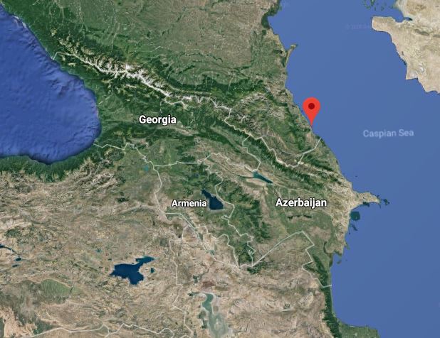
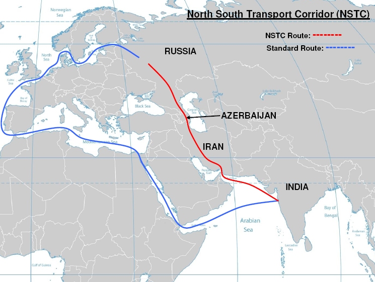
You might have seen the news about the North–South Transport Corridor, an arrangement to move freight via rail, road, and ship, among India, Iran, Azerbaijan, Russia, Afghanistan, Armenia, Central Asia, and Europe. But this project is focused on the first four of these, and it shows with the kickoff being a railroad-building project connecting Iran to Russia via Azerbaijan. Of course my first thought was: “Why not go through Armenia?” (see accompanying map).
Given the sense many Armenians have that Iran is very even handed, or even pro-Armenian, in its dealings with Armenia-Artsakh-Azerbaijan, this news may come as a bit of a surprise. It may be even more so when Russia’s participation in this arrangement is factored in, since that country is often (though frequently sarcastically) referred to as Armenia’s “big brother” and purportedly leans toward the Armenian side when it comes to Azerbaijan related issues.
Much as I would like to attribute this development to sinister intentions, the answer is really much simpler: The Caucasus Mountains. This range is very significant and forms a huge wall spanning the (very large) “isthmus” between the Black and Caspian Seas. The easiest way to get from south to north (or vice-versa) of these mountains is through the Derbent Pass, located on the Caspian Coast, in the Daghestan Republic of Russia. The city of Derbent is located some 25 miles from the Azerbaijani border. This pass has been a bone of contention and the cause of many a battle over the course of history precisely because of its strategic value as an easy route of passage.
All of this leads to the importance of our twin republics being integrated with the network of transportation infrastructure that is being developed in Asia, especially the Chinese initiative known as “Belt and Road” (in part a rebirth of old Silk Road). For a quick look at what this massive undertaking entails, see Inside ‘Belt and Road,’ China’s mega-project that is linking 70 countries across Asia, Europe, and Africa published by Business Insider.

I have seen some reports of Yerevan-Beijing talks. Presumably, this matter is being addressed. But given the hostility of our eastern and western neighbors, and the historically unreliable northern neighbor and its problems with Russia, Armenia/Artsakh’s only solid trade route is to the south. This is very dangerous, and points up the importance of Black Sea access, hence the restoration of Wilsonian Armenia to our control. Those Armenians who sneer at even the mention of regaining those lands, deeming it “impossible” or “unrealistic” or “unimportant relative to rebuilding the current republics” should view the matter through this prism and reconsider their dismissiveness. Heck, even a small “Republic of Hamshenia” that shares a border with the Republic of Armenia would be better than the current conditions. Recall that Hamshentzis are Islamicized Armenians who still speak a Western Armenian dialect and live in the northeastern corner of what is called Turkey.
Shifting to a geographically proximate, but otherwise unrelated, problem I stumbled on, let’s discuss Google Earth’s failure to delineate Artsakh. When viewing the vicinity of Derbent, I first noticed that Abkhazia and South Ossetia show up outlined in red on Google Earth, which got me thinking. So I looked, and Artsakh is not similarly delineated. After looking at problem spots I knew of around the world, I realized that the red lines indicate disputed borders or occupied territories. Arunachal Pradesh, Crimea, Cyprus, Egypt-Sudan border, Jammu, Golan Heights, Kashmir, Kosovo, Morocco-Western Sahara, West Bank/Gaza, and others in South America all have this marking, but not Artsakh. Why? It seems to me those Armenians who love to “live” on the “net” ought to take this matter up with Google and see to it that Artsakh gets its due respect.
So that’s two “assignments” in one article for readers- Armenian inclusion in budding transportation networks and Google Earth correction. Get to work and good luck.
***
Follow-up on last week’s “Turkish Racism” piece, see this video. About half-way through, you’ll see Turks walking behind Aram Hamparian and making the hand sign for Turkey’s extremist right wing “Grey Wolves.”


I don’t get it, the dream of a greater Armenia might keep the Armenians in Europe and the Americas bind together, but for Armenians living in Armenia is it not a price too high? Would it not be more beneficial for Armenia to have neighbourly relations with Turkey and Azerbaijan?
Don’t get me wrong, Armenia’s occupation of Nagarno-Karabakh is what propelled the rise of Turkic nationalism in Azerbaijan. As a result they are much closer culturally then say the other Turkic nations in central Asia. Yes they lost land, but they gained something so much more valuable; awareness of their nationality.