
An Open Letter to Acting PM Nikol Pashinyan
I have written an open letter to the Acting Prime Minister of The Republic of Armenia, Mr. Nikol Pashinyan, the general contents of which were the following:
These days the most urgent issue being discussed amongst all Armenians is the problem regarding the borders of the Republic of Armenia with the Republic of Azerbaijan. What we have presently are the borders inherited from the Soviet days. These borders were drawn on military topographic maps in 1929, which were approved by both parties in 1929 and later reapproved in 1969 by both Armenia and Azerbaijan. It should be noted that even after Stalin’s decision in 1921, to hand over which Nagorno-Karabakh, Qarvachar, Qashatagh and Eastern Syunik were handed to Azerbaijan, the borders between Armenia and Azerbaijan were different from what are in the above mentioned “official” maps.
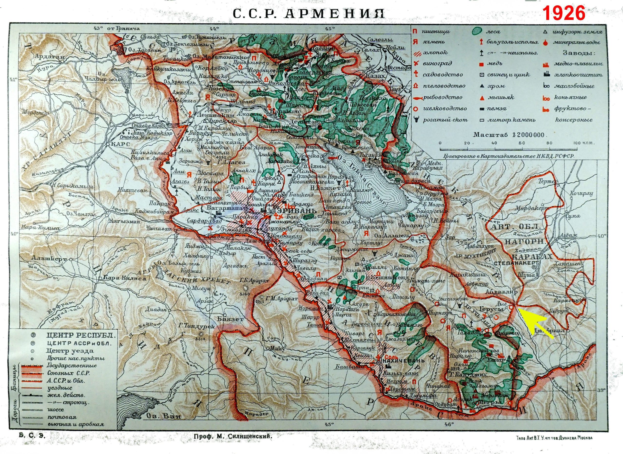
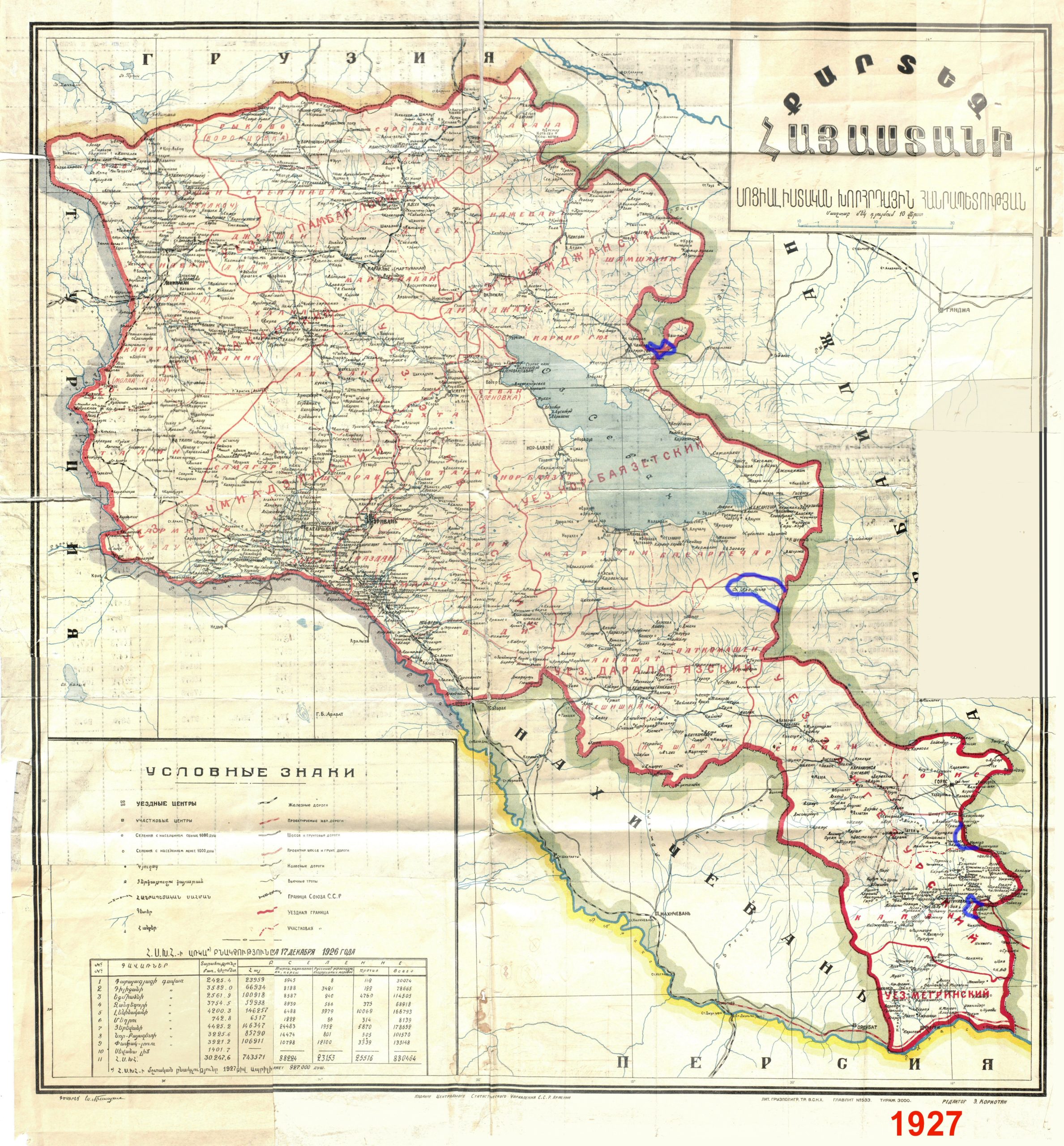
In the Great Soviet Encyclopedia, published in 1926, as well as in the 1927 map of the Soviet Socialist Republic of Armenia, prepared on the occasion of the 1926 census, the borders of Armenia are still those which were in 1922. Both these maps are reproduced at the end of this letter. Here the eastern and northern borders of Soviet Armenia are not the same as they are today. Among them, the enclaves given to Azerbaijan, including the Armenian regions of Al Lakes (south-east of Sevan), the eastern region of Shurnukh, the lands near the Kapan airport, Artsvashen are squarely placed inside the territory of Armenia. On the 1927 map, these areas, which were later “donated” to Azerbaijan, have been marked in blue. It is noteworthy that in those days the geographic division between Artsakh and Armenia was the Hakari (Aghavni) river only. And the above mentioned enclaves were absent.
Between the years of 1923 and 1929, by order of Moscow and the Trans-Caucasian Federation, without following the legal requirement of the Soviet law, with no due respect to the human rights of the local villagers, hundreds of square kilometers of their lands, forests and pastures were transferred to Azerbaijan. The main reason for this transfer was the creation of a new county of “Red Kurdistan”, a buffer zone between Armenia and the rest of Azerbaijan. The excuse for giving Armenian lands and pastures to Azerbaijan was to provide the Kurds with sufficient pastures for grazing their flocks, which, the mountainous region allocated to them lacked. However, in 1930 the creation of Red Kurdistan was annulled yet all the Armenian lands, earmarked for the Kurds, instead of being returned to Armenia, were appropriated by Azerbaijan.
During the following decades three Azerbaijani enclaves were created inside the territory of Armenia, which were handed over to Azerbaijan. The reason cited for their creation was that these contained villages populated by Azerbaijani Turks, therefore it was politically correct for them to be under Azerbaijani control. The following question arises; by the same token the region of Artsakh, where over 100,000 Armenians lived, should have made an Armenian enclave located inside Azerbaijan. Clearly the communist leaders could have hardly have entertained such an argument…

The geographical location of the three enclaves have been chosen very strategically. All three are placed directly on the highways connecting Armenia with its neighboring countries, while the meandering borders of Goris-Kapan and Ijevan to Noyemberyan highways force the Armenian highway to pass in and out of Azerbaijani territory many times. These type of border markings could only have one purpose; handing over the control of Armenian logistical communication with the outside world to Azerbaijan.
It must be noted that the Azerbaijani territories, through which the Armenian highways are crisscrossing are generally uninhabited and mostly unsuitable for cultivation, except for one instance. At the first glance the borders and enclaves seem to be laid out in an illogical manner, until one considers their raison d’être, and cannot fail to conclude that they have been custom made to fit the above-mentioned purpose.
From the legal point of view, the 1926 and 1927 maps reproduced here could be considered “unofficial” as they are not the mutually approved documents, but here is the key nuance. Back in 1922-23 the Soviet Union published detailed military maps showing the borders adopted at the time between Armenia and Azerbaijan. These, most certainly show the territories “dedicated” to Azerbaijan from the lands of Armenian Republic. However, copies of these maps of Armenia’s borders have not been given to the Armenian authorities. They are available only in Moscow and Tbilisi. As far as we are aware, Armenian authorities so far have not been able to secure copies of these maps, which are about our borders.
But why: After all, these are the maps of our country’s borders?
Without having copies of these early Soviet maps of the Soviet Republic of Armenia, and checking the reason for the later enforced alterations, it would be impossible for Armenian specialists to make final and informed decision on the borders and delineate them; therefore every effort must be made to obtain the copies of these maps, through the highest level.
Rouben Galichian
Honorary Doctor of NAS of Armenia
June 7, 2021
Yerevan
Highly informative and commendable.
Lotfali Khonji
It is reported that when the Soviet Union was dissolved in 1991 both Azerbaijan and Georgia declared that their Republic was the successor of the First Republic in 1918. The League of Nations approved Armenian borders of First Armenia borders in Feb.24, 1921 where Artsakh was not in Azerbaijan. The question is why Azerbaijan is claiming Artsakh as Azeri territory since this territory was not a part of official Azeri territory during the First Azeri Republic in 1918? Why Armenia in 1991 did not declair the successor of the First Republic?