
Unseen Armenia: Herher and the Vayotssar Volcano Church
Herher is a village in Vayots Dzor marz (“Valley of Woe” province), not far from the town of Vayk. From the main highway, a road to Herher passes between scenic cliffs. When the Soviet-era reservoir to the right was built, it inundated some Armenian villages. Along its shore, remnants of the submerged villages can be found. After passing a spring and some khachkars (stone crosses), a steep stone hill appears beyond a wide field to the right. Atop that conic stone elevation is the Chikivank or Soorp Gevorg Lusavorich shrine—a small church dated 1297.
Upon entering the center of Herher, my friend Vova and I stopped at the small store next to the 19th century Soorp Gevorg basilica. We had questions about the local monuments. The woman tending the store responded, “If we are going to talk, you need a cup of coffee,” and immediately prepared coffee for me. She then introduced us to a young man who accompanied us part way to Chikivank.
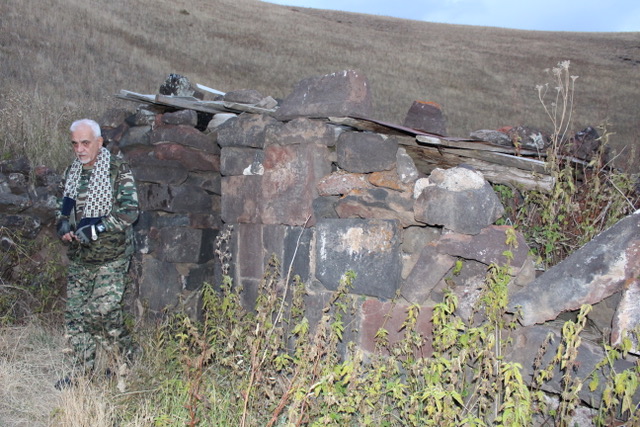
Chikivank, or Soorp Gevorg, can be approached within about 100 meters/yards by driving along a jeep track through some fields and orchards. Then it’s a brief, steep climb requiring cautious footing to the church. The church is small, able to accommodate perhaps five to six people at most. Moreover, the hilltop leaves little room for many people to congregate around the church. This interesting vank presents a superb view of the Herher river valley.
A couple of years ago, after receiving directions to Herher’s Soorp Sion vank (perhaps a hermitage), I hiked through orchards above the west bank of the Herher river, looking for the bridge to cross on the way to the vank. I spent over an hour looking for a “bridge” and never found it. This time, after enjoying a great deal of hospitality by a local family, we set off again with a small group of local villagers. We parked our car at nearly the same point where we parked during my previous visit. Then we hiked down to the river bank. There, across the river, invisible from above, was a crudely built 10 to 15 foot-long cement slab placed over a few pipes spanning the river. The cement slab was tilted towards the right. I could imagine that a bit of frost on this “bridge” could send someone slipping into the river. The villagers commented that they helped fund the construction of this “bridge” by a government agency a number of years ago, and this was the result! I shared their indignation.
Beyond the footbridge is a short, but steep stone hill. The hilltop is a bit more spacious than the Chikivank hill, but not much more so. Atop the hill are three adjoining structures connected side by side, with the leftmost and most damaged structure believed to be a chapel, perhaps used for baptisms. To its right, south of the chapel, is the Soorp Sion church, a small church with its altar in an apse facing east. On the opposite, west wall, is another apse, mirroring the one over the altar, with a door exiting the church. The door, however, is walled in with stones. To the right, at the southern end of the three structures, is the Soorp Astvatsatsin church with two side by side altars on the east side. Entrance to the complex of two churches and chapel is via the rightmost Soorp Astvatsatsin church. On the small hilltop is a collection of beautiful khachkars, with a number of inscriptions on the church walls. The two churches present two different forms of symmetry: Soorp Sion church exhibits front-back symmetry with the apse at the altar on the east side, and an apse on the opposite, west wall; while Soorp Sion displays left-right symmetry with two altars facing east, with the left and right half of the church mirroring each other. Both structures are unusual, and perhaps unique.
The vank is attested as early as the eighth century. The Soorp Sion and Soorp Astvatsatsin churches are dated to the 11th and 13th centuries respectively. Our village guides expressed considerable concern for the preservation of these cultural monuments and advocated more research into the region’s history. In medieval times this area was under the tutelage of the Orbeli princely family.
Back in Herher a woman told us an incredible story: the existence of a church in the crater of a nearby extinct volcano. She claimed she drove there, into the crater and to the church! After a few sources confirmed the church’s existence we planned a subsequent visit to see this church.
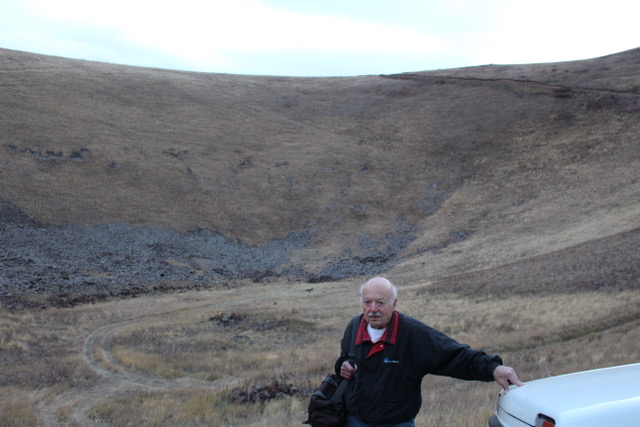
To the north of Herher, over a bad but passable road, is the village of Karmrashen with a number of abandoned houses. From there, over an even worse road, we headed to the Vayotssar (also Vayots Sar) extinct volcano, about six to seven kilometers to the west, rising about 500 meters (1500 feet) above its surroundings to 2568 meters (about 7704 feet) above sea level. The volcano’s crater is 125 meters (375 feet) deep. Vayotssar appeared smooth and almost semi-spherical from Karmrashen. A jeep track ascending the volcano was extremely narrow and deeply rutted. Fortunately, our four-wheel drive Niva sits high off the ground and is narrow, but we still were concerned about our wheels slipping into the deep ruts. We made it to the rim of the caldera. Looking into the caldera there appeared jeep tracks leading to what seemed to be a pile of dark rocks on the caldera floor. Besides dried vegetation there also appeared to be black and grey material; probably volcanic ash. After a brief stop at the rim of the volcano we apprehensively headed into the caldera. Vova, who was driving, exclaimed, “If I did not do this, I’d always regret it!” What appeared to be a pile of rocks from above, even through the telescopic lens on my camera, was indeed a small chapel built of dark colored volcanic stone, partially ruined, but with a wood roof and an intact altar. There was room in the chapel for only three to four people. Next to the church was the foundation of another small building. A couple of other small rock piles perhaps signified the presence of additional structures. It is told that when villagers, during a drought, planted an iron cross in the volcano and poured salt over it, rain came. We did not linger long. It was getting dark, and rain was threatening. We did not want to drive out of there at night during a rainstorm. Photographs taken at dusk were not as good as I hoped for.
I’ve asked a few knowledgeable people about the history of the church, but no one seems to have much information. Those whom I’ve asked tell me that as far as they know, no research or archaeology has been done at this site. Regarding the name of the church, locals call it Vayotssar Yegeghetsi (the Vayots Mountain church). Historian Stepanos Orbelian (1250-1305) stated that in Vayots Dzor a volcano erupted in 735 AD, causing 40 days of darkness and a great deal of destruction. Near the town of Malishka is the destroyed village of Moz, said to have been destroyed by Vayotssar’s eruption. Vayotssar’s eruption, however, is disputed.

Thank you Mr. Daghdigian for a very informative article.
I would like to supplement some information about Chiqi Vanq, which you describe briefly. Chiqi Vanq is known among locals to have curing properties for skin diseases. Locals go there with a Matagh (animal sacrifice) to seek a cure. I have documented such an occurrence in my blog 10 years ago: http://lettersfromarmenia.blogspot.com/2009/07/letter-28-healing-at-chiqi-vanq.html
The photos can be seen at: https://s192.photobucket.com/user/aterjanian/library/Matagh%20at%20Chiqi%20Vanq?page=1
Please come and visit us when you are near Yeghegnadzor.